You have 0 items in your cart

Surrounded by the Himalayas and the rivers of Punjab, Azad Jammu & Kashmir (AJ&K) spans 13,297 km² of valleys and forests. With over 4.46 million people across ten districts, it reflects resilience, faith and natural splendour — the living heart of the Kashmiri spirit.
These timeless virtues define Kashmiri identity — a culture rooted in faith, humility, and resilience. Each pillar reflects a moral beauty that continues to guide generations across the valley and the diaspora.
Deep politeness and care in speech and conduct. Respect for elders, for words, and for the presence of Allah in every interaction.
The quiet endurance of hardship with faith — the strength that has carried Kashmiris through centuries of struggle and change.
Love for nature and humble living. A heart detached from excess, finding richness in gratitude and peace in what is pure.
Dignity in every deed. Integrity, loyalty, and moral strength that bring respect to one’s family and community.
The art of welcoming guests as a blessing from Allah — generosity that warms hearts and unites people across every boundary.
The valleys of Neelum, Bagh, Muzaffarabad, and Kotli each tell their own story of heritage, beauty, and resilience. Discover the regions where our projects bring hope and development.
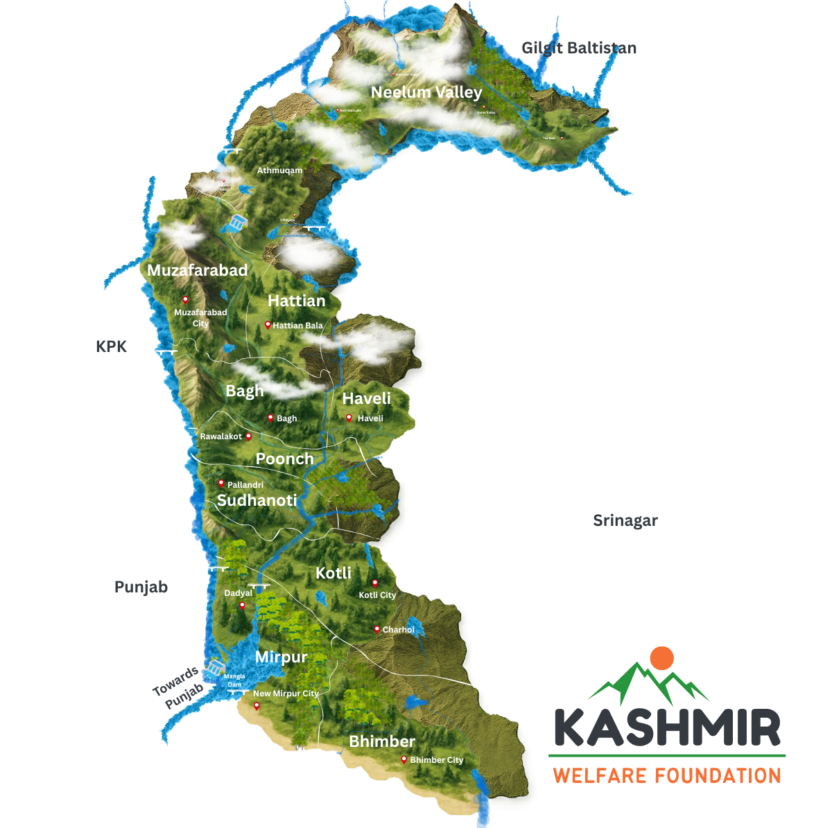
A visual map of Azad Kashmir showing all the districts natura topography, waterways and glaciers.
| Region | Area (sq. km) |
|---|---|
| Azad Jammu & Kashmir (AJ&K) | 13,297 |
| Gilgit–Baltistan | 77,676 |
| Indian-administered Jammu & Kashmir | 93,708 |
| Under Chinese Administration (Aksai Chin) | 37,555 |
| Total Area of the Historical State | 222,236 |
| Length of Line of Control (LoC) | ≈ 528 km |
| Description | 2017 Census | 2023 (Comfirmed) |
|---|---|---|
| Total Population (Including Pakistan) | 207,774,520 | 241,499,431 |
| Total Population (AJ&K) | 4,032,363 | 4,460,971 |
| Male Population (AJ&K) | 1,966,629 | 2,176,750 |
| Female Population (AJ&K) | 2,065,348 | 2,283,797 |
| Urban Population (AJ&K) | 702,945 | 835,437 |
| Rural Population (AJ&K) | 3,329,418 | 3,625,534 |
| Average Annual Growth Rate (AJ&K) | 1.61% | 1.61% |
| Population Density (per sq. km) | 303 | 335 |
| Area (sq. km) | 13,297 | 13,297 |
| District | 2017 Census | Projected 2023 |
|---|---|---|
| Muzaffarabad | 0.651 M | 0.733 M |
| Neelum | 0.190 M | 0.216 M |
| Hattian (Jhelum Valley) | 0.226 M | 0.250 M |
| Bagh | 0.372 M | 0.415 M |
| Haveli | 0.146 M | 0.159 M |
| Poonch | 0.500 M | 0.536 M |
| Sudhnoti | 0.298 M | 0.326 M |
| Kotli | 0.774 M | 0.856 M |
| Mirpur | 0.457 M | 0.505 M |
| Bhimber | 0.419 M | 0.465 M |
| Total AJ&K | 4.032 M | 4.460 M |
A comparative overview of key social and economic indicators between Pakistan (National) and Azad Jammu & Kashmir (AJ&K), highlighting progress in health, education, and living standards across the region.
| Indicator | Unit | National | AJ&K |
|---|---|---|---|
| Infant Mortality Rate | Per 1,000 live births | 62 | 47 – 51* |
| Maternal Mortality Ratio | Per 100,000 live births | 186 | 104* |
| Literacy Rate | Percent | 62.4% | 77.5% |
| • Male Literacy | Percent | 73.0% | 87.8% |
| • Female Literacy | Percent | 51.5% | 68.2% |
| Life Expectancy at Birth | Years | 67.3 | 67.3 |
| Stunting (Height-for-Age, under 5) | Percent | 37.6% | 30 – 24.2* |
| Wasting (Weight-for-Height, under 5) | Percent | 7.1% | 6.4 – 4.4* |
| Immunisation Coverage | Percent | 66% | 75% |
| Sex Ratio (M:F) | Ratio | 105 | 95 |
| Urban Population | Percent | 36.38% | 17.43% |
The State of Azad Jammu & Kashmir lies between longitude 73°–75° and latitude 33°–36°, within the majestic Himalayan belt. Its landscape is dominated by mountains, valleys, and deep ravines — a terrain both breathtaking and challenging, shaped by glaciers, avalanches, and centuries of erosion.
The northern districts — Neelum, Muzaffarabad, Hattian, Bagh, Haveli, Poonch, and Sudhnoti — are primarily mountainous, forming part of the Greater and Lesser Himalayas. Peaks in the far north rise to 6,359 meters above sea level near the Nanga Parbat massif, while alpine pastures and steep ridges define the upper valleys.
In contrast, the southern districts of Kotli, Mirpur, and Bhimber transition into gently undulating plains that resemble the Punjab lowlands. Here, older rock formations and compact hilly terrains create a blend of plateaus and fertile valleys — vital to the region’s agriculture.
These mountain ecosystems are ecologically fragile yet rich in biodiversity. Small landholdings, limited arable land, and steep slopes make farming difficult, but they also foster a resilient way of life rooted in harmony with nature.
The region’s beauty and vitality are sustained by its fast-flowing rivers — lifelines that cut through valleys and support both agriculture and hydropower. The three principal rivers of AJ&K are the Neelum, Jhelum, and Poonch.
From just a handful of schools at independence to a diverse network of universities and colleges today, Azad Jammu & Kashmir’s education system has transformed dramatically over the decades. In 1947, the region had only 254 primary schools and one intermediate college. By 2023, it proudly hosts thousands of educational institutions at every level — empowering generations through learning and opportunity.
Since 1947, healthcare in Azad Jammu & Kashmir has made remarkable progress — growing from just 30 hospital beds to nearly 3,000 by 2023. Yet, the region’s mountainous terrain and dispersed population continue to pose challenges. Today, AJ&K averages one bed per 1,512 people — slightly better than Pakistan’s 1,608 ratio — and shows stronger performance in maternal and infant health indicators. However, doctor availability remains limited, with one doctor serving almost 3,900 people.
Despite geographic challenges, Azad Jammu & Kashmir continues to expand its healthcare network — from hospitals and rural health centres to trained medical staff. These progress bars compare AJ&K’s current capacity to national averages, highlighting areas of growth and ongoing need.
With over 42% of its land under forest cover, Azad Jammu & Kashmir stands as one of South Asia’s most ecologically diverse mountain regions. Its forests stretch from tropical lowlands to alpine glaciers — sustaining unique plant life, wildlife, and communities that depend on them.
Out of AJ&K’s total geographical area of 1.33 million hectares, approximately 0.567 million hectares (42.63%) are managed by the Forest Department. Productive forests make up 67% of this area, providing timber, biodiversity, and watershed protection. Each person in AJ&K has about 1.09 acres of forest area and a standing volume of 527 cubic feet of wood.
Communities have traditional rights over forest resources — using timber for housing and firewood, as many mountain households rely on wood for energy. On average, three trees are used annually per household for fuel, and about five trees are needed to rebuild a roof every 8–10 years.
The forests range from Acacia and Shisham in the southern plains of Mirpur and Bhimber, to Deodar, Fir, and Pine in the alpine valleys of Neelum and Leepa. This vast elevation gradient hosts nearly every Himalayan vegetation type — from tropical dry forests to subalpine meadows.
AJ&K’s plant life reflects its varied climate and elevation. In the south, species such as Acacia nilotica, Dalbergia sissoo (Shisham), and Ziziphus mauritiana thrive, while the northern temperate and alpine zones support Deodar (Cedrus deodara), Fir (Abies pindrow), Kail (Pinus wallichiana), and Poplar species.
The region also hosts an exceptional range of medicinal herbs — including Kuth (Saussurea costus), Patrees (Aconitum heterophyllum), Gaozaban (Arnebia benthami), Banafsha (Viola canescens), and Guchi (Morchella esculenta) — all prized for traditional healing and export.
AJ&K’s forests and altitude zones create ideal habitats for diverse wildlife. Rare species such as the Snow Leopard, Musk Deer, and Markhor roam its northern ranges, while pheasants and partridges fill its valleys and forests.
Azad Jammu & Kashmir’s total forest cover spans 0.567 million hectares. Of this, nearly two-thirds are classified as productive forests, vital for timber and watershed protection, while the remaining one-third are non-productive but equally critical for biodiversity and soil stability.
Blessed with majestic mountains, alpine lakes, and centuries-old heritage, Azad Jammu & Kashmir is a natural paradise waiting to be explored. Its breathtaking landscapes and diverse culture make it one of Pakistan’s most promising regions for sustainable and adventure tourism.
Each district of Azad Jammu & Kashmir tells a story — from the serene mountain valleys of Neelum to the vibrant lakes of Mirpur. Click a district to explore its landscapes, heritage, and community initiatives.
Journey through centuries of Kashmir’s history — from ancient dynasties and cultural golden ages to the year of partition and beyond. Explore how each era shaped the Kashmiri identity we preserve today.
Before the partition, Kashmir was a land of diverse rulers, thriving culture, and evolving identity. Discover how centuries of history shaped the valley we know today.
Read Kashmir Before 19471947 marked Kashmir’s defining crossroads — Dogra rule, British influence, and the hopes of ordinary Kashmiris as their homeland entered a new age of uncertainty and change.
Read Kashmir During 1947The partition reshaped Kashmir’s destiny — dividing families and borders, giving birth to Azad Jammu & Kashmir, and beginning a new era of resilience and identity.
Read Kashmir After 1947